|
|

|
  
Features
Update 2018/3/7
Arctic
WHILE EUROPE FROZE, THE ARCTIC REACHED RECORD HIGHS
This story is brought to you in part by Borrum Energy Solutions
By Stuart Smith
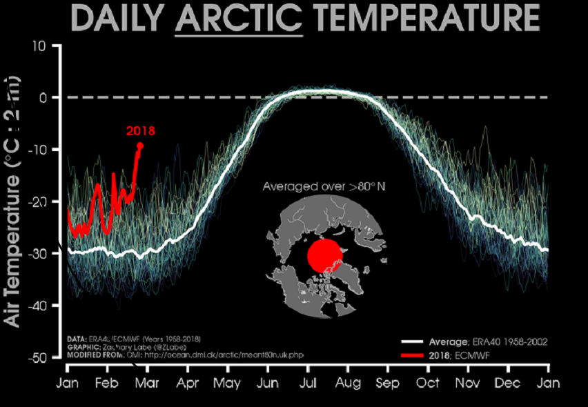
For the fourth winter in a row, temperatures in the Arctic were abnormally high. During the last week of February, although still generally below freezing, they were 10C to 20C warmer than average.

Graphic by Zack Labe
Zack Labe, a climate scientist at University of California in Irvine who produced the above graphic, explained: "Temperature swings and variability are quite common during the Arctic winter, and unusually above average temperature intrusions (e.g., briefly >20C above average) have occurred in the past. But early analysis suggests this event to be of unusual magnitude and duration."
Kent Moore, Professor of Physics at the University of Toronto, studies how the atmosphere, oceans and sea ice interact at the Arctic and high northern latitudes. He was one of the first scientists to discover 'warm air intrusions' in 2015, which he explained were behind February's warming event:
"These things have been happening all the time. The earliest one I could find was in 1959, and people have actually gone back using data from Russian ice stations in the 1930s and 40s and found evidence of these intrusions then. So, they're nothing really new."
However, "This intrusion event was different than most of the ones we've looked at before. What happened in February is rather than transiting across the North Atlantic (the storms) went straight up the east coast of Greenland."
This is exceptional, because when a warm air intrusion usually occurs, it only penetrates north once it has reached the Barents Sea, a region far across the North Atlantic Ocean and far further west than Greenland's east coast.
So why did it happen on this occasion? Professor Moore does not believe we know the direct relationship yet, but thinks it is probably related to the reason Europe suffered from unusually cold temperatures at the same time: an SSW - or a sudden stratospheric warming.
"These (SSWs) occur infrequently. Maybe once every few years. (This one) appeared to be quite intense." They occur when cold air which is normally trapped over the Arctic escapes. In this case, it headed south over Siberia, and then east over Europe, bringing the cold with it.
"That easterly flow was a symptom of the (SSW) which also caused these storms to go up the north coast of Greenland. So, these two are related."
And this is why Professor Moore finds these events so interesting:
"We tend to think of the Arctic as being some remote place that maybe doesn't impact us in mid-latitudes, but this event shows clearly that there is huge coupling between mid-latitudes and what happens in the Arctic. And that can go both ways. This is an example of just how coupled this system is. And it's coupled both horizontally (things in Europe affect the Arctic) and also vertically (things that happen in the stratosphere have an impact right down in the oceans). It is a really complex system and it's all coupled together, and I don't think we should be complacent that climate change isn't going to impact us. It is, and this is another canary in the coal mine telling us we've got to get our act together."
Zack Labe agrees: "the much more important takeaways are the long-term trends in the Arctic. Temperatures continue to warm more than twice as fast as the global average ('arctic amplification') along with a loss of sea ice. While this was an extreme weather event, the long-term trends are more important from a climate perspective."
Professor Moore adds, "If you look over the last decade, we're seeing changes in the Arctic summer, but the winters haven't really seen a large degree of anomalous events (apart from these warmings)."
"But now we're seeing every winter is a little bit different than what we expect in the Arctic and I think that is an indication. We're now starting to see changes to the sea ice in the wintertime. This thinner ice is more mobile, it's easier to flow around. So, we're starting to see that the winter climate in the Arctic is becoming more variable. And I think that is cause for concern."
ssmith@watertoday.ca
|
|
|
Have a question? Give us a call 613-501-0175
All rights reserved 2025 - WATERTODAY - This material may not be reproduced in whole or in part and may not be distributed,
publicly performed, proxy cached or otherwise used, except with express permission.
|
| |