|
|

|
  
Feature
Update 2021/2/9
Conservation
 SEEING RED: BC'S LAST PRIMARY FORESTS SEEING RED: BC'S LAST PRIMARY FORESTS
By Suzanne Forcese
Update: original article:
CANADA’S GROWING WOOD PELLET EXPORT INDUSTRY THREATENS FORESTS, THE CLIMATE, AND WILDLIFE

Photo Courtesy Conservation North
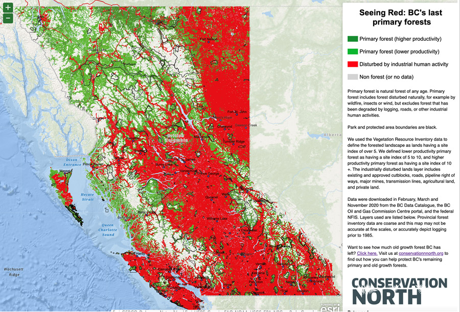
Forest-focused conservation group, Conservation North, has released both the first province-wide cumulative impacts map and the first visual account of the last remaining old growth forests.
“They are the first tools of their kind made by the public for the public,” explains Conservation North’s outreach coordinator Jenn Matthews.
This interactive mapping project, dubbed ‘Seeing Red’, shows where there are opportunities to conserve primary forests, as well as where management for restoration and/or production of wood products are a better option. Both maps were created using data from the provincial and federal governments.
According to Matthews, the group “wanted to show what has actually happened in those forests that most of us can’t see.”
Primary forests – forests that have never been disturbed by industry and where natural processes dominate, are threatened by industrial logging and a burgeoning bioenergy industry. Lower productivity forests, once ignored by the timber industry, are now targeted for pellets.
suzanne.f@watertoday.ca
|
|
|
Have a question? Give us a call 613-501-0175
All rights reserved 2025 - WATERTODAY - This material may not be reproduced in whole or in part and may not be distributed,
publicly performed, proxy cached or otherwise used, except with express permission.
|
| |