Landsat 9 - A joint NASA/USGS mission captures impacts of climate change providing critical data for natural resource management
By Suzanne Forcese
“NASA will continue to work with USGS (U.S. Geological Survey) to strengthen and improve accessibility to Landsat data so decision makers in America – and around the world—better understand the devastation of the climate crisis, manage agricultural practices, preserve precious resources and respond more effectively to natural disasters.” --Bill Nelson, NASA Administrator
The Great Lakes serve as sources of freshwater, recreational activity, transport, and habitat for the upper-midwestern United States and Canada Water quality remains a high priority.
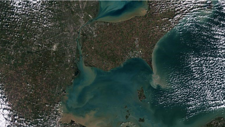
Recently released image of Lake Erie and Lake St Clair Algae & sediment swirl in Lake Erie and Lake St. Clair affect water quality in both Canada and the United States. Images taken every 8 days will provide valuable data for water management in Windsor, Ontario and Detroit Michigan and surrounding areas - Courtesy NASA/USGS
Landsat 9 is similar in design to its predecessor Landsat 8, which was launched in 2013 and remains in orbit, but features several improvements. The new satellite transmits data with higher radiometric resolution back down to Earth, allowing it to detect more-subtle differences, especially over darker areas like water or dense forests. For example, Landsat 9 can differentiate more than 16,000 shades of given wavelength colour. Landsat 7, the satellite being replaced, detects only 256 shades. This increased sensitivity will allow Landsat users to see much more subtle changes than ever before.
Landsat 9 carries two instruments that capture imagery; the Operational Land Imager 2(OLI-2) which detects visible, near-infrared and shortwave-infrared light in nine wavelengths, and the Thermal Infrared Sensor 2 (TIRS-2) which detects thermal radiation in two wavelengths to measure Earth’s surface temperature and its changes.
These instruments will provide Landsat 9 users with essential information about crop health, irrigation use, water quality, wildfire severity, deforestation, glacial retreat, urban expansion, and more
NASA’s Landsat 9 team is conducting a 100-day check-out period that involves testing the satellite’s systems and subsystems and calibrating its instruments in preparation for handing the mission over to USGS in January 2022. USGS will operate Landsat 9 along with Landsat 8, and together the two satellites will collect approximately 1,500 images of Earth’s surface every day, covering the globe every eight days.
“The incredible first pictures from the Landsat 9 satellite are a glimpse into the data that will help us make science-based decisions on key issues including water use, wildfire impacts, coral reef degradation, glacier and ice-shelf retreat and tropical deforestation. This historic moment is the culmination of our long partnership with NASA on Landsat 9’s development, launch and initial operations, which will better support environmental sustainability, climate change resiliency and economic growth – all while expanding an unparalleled record of Earth’s changing landscapes.” -- Dr. David Applegate, USGS Acting Director
Landsat 9 data will be available to the public, for free, from USGS’s website once the satellite begins normal operations.
All rights reserved 2026 - WATERTODAY - This material may not be reproduced in whole or in part and may not be distributed, publicly performed, proxy cached or otherwise used, except with express permission.